J. H. Martineau Plat Survey of 1863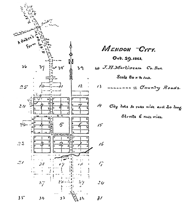
1n the summer of 1859, a small survey was created for the “North Settlement,” which was later that year to become known as Mendon. Jesse W. Fox, Sr. was the surveyor whom I believe to have laid out the first nine block plat for the early settlers on August 10, 1859. The first survey was made from a reference point on the south-east corner of the town square, on what we know today as block five. With the town square laid out, and a ring of eight, ten-acre city blocks surrounding it, the future looked most optimistic for Mendon’s founding fathers. This did not last and changed in a hurry as the Indians, were not very keen on these new peoples taking up permeant homes on their camping, hunting and grazing grounds. Several Indian camp sites existed in greater Mendon area, the Shoshone use of them perhaps going back in time, several hundred years. Even then the Shoshone tribe most likely would have camped and used sites that had been used by other tribes previously, dating back as far as the Fremont time period. With the many clear and cool streams, rising from springs that flowed into the Little Bear River, wood for fire and the refreshing shade of the trees in summer, this must have been a favored stopping place for many generations. From one camp in particular, near the first cattle guard entering the National Forest lands above Mendon, they could see in the days before smog, North to Battle Creek, Idaho and South to Paradise, two other favored stopping places in the Cache Valley. The Indians would harvest the seeds from ripe grasses that grew in this area, each fall. After the harvest they would set fire to the grass, having learned many generations ago that the land produced a better crop the year following a fire. Many folks in the local area have cursed the sheepmen for bring back the sagebrush to the Cache Valley floor. But, it was not the sheep nor any-other creature, it was that the valley floor was no longer being burned out in the fall, the settlers of Mendon and Wellsville being among the first to cause this practice to cease. Game of all types, including buffalo were plentiful here, as noted by the fur trapper journals of the late 1830’s and early 1840’s.
So with this uneasy tension between the pioneers and the native peoples, many of Mendon’s early settlers spent the winter of 1859 to 1860 at Maughan’s Fort, or at what would later become known as Wellsville. A few families did winter over in Mendon that first cold winter of 1859-1860, they did so not on the lots nor homes they had hoped to construct upon them, but in a row of two log cabins, built fort style. These cabins were laid out in rows, one on each side of what we know today as Center Street in Mendon. The six rod space for center street was left open between the opposing rows of cabins and a provision for a north-south road with a six rod space along the Main Street axis was left open as well. Those first eight or so families spent the winter huddled around the intersection of Center and Main Streets. (I should note here that Mendon City did not have these proper street addresses until the mid 1970’s.) As time passed and more settlers joined with those already here, the size of the Mendon Fort increased as well, to, two blocks in total length, this also would be the maximum size of the fort at Mendon. The fort would extend from 100 East to 100 West today, following Center street as the East-West axis. I know some people think the fort ran around the town square . . . and was made of pencil shaped logs, but it did not, it was laid out as I have referenced above. At its peak there were some twenty odd cabins constructed in the fort. The spaces between the cabins were to be blocked, in case of attack, with wagons or poles, to form the protection of a fort. This was never done nor needed in the five year period of the Mendon Fort, from summer 1859 until the spring of 1864.
This new expanded plat map was needed because of the growth Mendon experienced, in the five years it was held up due to Indians troubles. Also there was a constant stream of new settlers arriving from the missions in Europe, with Great Britain and the Scandinavian countries providing the bulk of these converts to the Church of Jesus Christ of Latter-Day Saints and emigrants to the Territory of Utah, whom all needed homes to live in and farms to support them. So on the 29 day of October, 1863, J. H. Martineau set forth this expanded plat map of Mendon City. It would be another seven years before incorporation of the city proper by the Territorial Legislature of Utah, then located at Fillmore, to provided a legal charter for Mendon, but it was as from the first laid out to be a city. Each lot was one and one-quarter acre in size, eight lots making a block of ten acres. With the Indian problems solved, for the time being, it was thought safe to move out from the fort in the spring of 1864, and this plat was required to have an orderly transition from the Mendon Fort to Mendon City. With the arrival of spring, the old fort was broken up and the cabins were moved to locations decided over the winter. The families seemed to settle into the same groups they arrived with, friends living next to friend, families taking up the front portions of whole blocks. Bishop Andrew P. Shumway had his home, west across the road from where the new 1865 rock church was going to be built, his father’s place on the south corner of the next block, his mother-in-law on the same corner of the block north of him. James G. Willie would be his neighbor just to the north of him and the ward tithing barn and corals to the south of him. The Bishop handled all lot and land assignments at this time. No land was given to speculators or such in these times, even single men were looked upon very carefully before being granted a city lot and farm.
The plat map above shows clearly the first nine blocks and the space added for nine more. Provisions were made at this time, for the city to expand up to 40 blocks, but there was not a need at this time. That would come a little later in the century, the town had enough for now and a efficient use of planning and zoning came by default with the wide streets and public areas built into Mendon from when the first line was drawn.
![]()